It's been a month. I suppose I should post something. Here's what I did last weekend.
A couple months ago Kate let me know that she was gonna be heading to Pocatello to stay with our friend Shannon and go to a
DOCNA trial. I decided that I needed to get some climbing done and a change of scenery wouldn't hurt either. Also I didn't want to be left alone with the cats for a weekend. So I decided to tag along with Kate for the weekend, bring my bike, and ride
up Mink Creek & down Arbon Valley on Saturday.
So off I went with chamois butter in my shorts. Rode six miles and stopped at the agility trial along Quinn Rd. A perfect place to stretch & refill my water bottles before starting in earnest. Continuing on, I headed south into town, turned down Garfield Ave, and rode past the hovel that Kate & I had the great misfortune of calling home for three years. The last time I'd ridden these roads, I considered the eight-mile ride from there up to the NWS office near the airport to be long.

After passing an old man riding a bike & talking to himself on Garfield, I hopped back on the main drag at Benton St and continued south out of town. Watched a kid barrelling down a hill out of a side street and onto the main drag, almost getting himself run over. My first little rest stop was at the mouth of Gibson Jack Creek - about 14 miles into the ride. The road was about to turn up Mink Creek Road. From there I'd gain about 1000 feet through some small rollers for a few miles and then hit the steep 780-foot climb. So I pulled into Gibson Jack Road, drank some gatorade, and ate a Clif Bar before continuing on.
Two thirds of my way through the rolling section, I entered the Caribou National Forest. There was a little turn-out there so I pulled over again to stretch & empty my bladder. I learned a couple things here that I should have learned a long time ago: 1) all else being equal, the inside of a curve in the road is better for hiding from traffic than the outside of a curve; and 2) when hiding from traffic to pee on the outside of a curve, it is more prudent to ensure that trees are obscuring the view of you from both legs of the turn than from the apex of the turn. But I had a nice view of Scout Mountain from there, about 5 miles away over some lower hills in the middleground (the first picture).

And so I continued on up the hill. The steep part wasn't really all that steep, and it was less of a challenge than I thought it would be though I was still very happy to round the last curve and see Crystal Summit. Not a single car passed me on the way up - I thought that was odd. The second picture is a view looking from Crystal Summit into Arbon Valley. The snow-covered mountain on the far horizon is called Deep Creek Peak. It's a little over 18 miles away from Crystal Summit (straight-line distance), and my ride was to take me within about eight miles of it.
The ride down the back side of Crystal Summit was really fun. Steeper and twistier than I remembered it being from the one or two drives I took that way back when I lived in Poky. An excellent time. A somewhat close encounter with a bull got the old heart racing a bit, and a longer ride south than I was expecting got me to pull off the road and check my map. But all was well. And the road kept going down and down and down. I thought I was gonna have to make another climb that I missed while studying the route. But that climb never came. I finally came to the end of S Mink Creek Road and turned north on Arbon Valley Road - mile 37 of the journey and the start of the homeward leg.

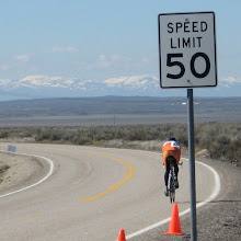
Still heading down a gentle rolling grade with a small tailwind, I was sustaining 25 MPH and grinning ear to ear right about that time. But somewhere around mile 45 or 50, I started realizing that I hadn't brought enough food. I brought enough for the ride itself, but I failed to realize that I'd be riding right through lunch time. I was confident that I wouldn't be so grossly undernourished that I wouldn't get home, but I knew I was in for a struggle for the last few miles. The third picture is looking south along Arbon Valley Road to Deep Creek Peak (very roughly ten miles away) from a point near where I came to this realization.
So the last fifteen miles or so was less enjoyable, but only partially because of the lack of nutrition. Around the start of the final fifteen, Arbon Valley opened up onto the Snake Plain. As a result, the wind went from being at my back to kicking me right in mouth. Less enjoyable. And the terrain became flat so the road became straight. Less enjoyable. But hey, it was still more enjoyable than . . . well than a heck of a lot of things. All told, I figured I got about 2200 feet of climbing over 70 miles of beautiful, lightly traveled roads through montane aspen stands and sage covered valleys.
 That was my time today over the ten-mile Hubbard Time Trial. 10 miles in 26:13 works out to 22.9 miles per hour. That far surpassed both my time in the Broome TT and my expectations for the evening (though it was about in line with my hopes for the evening).